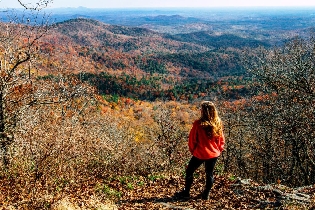
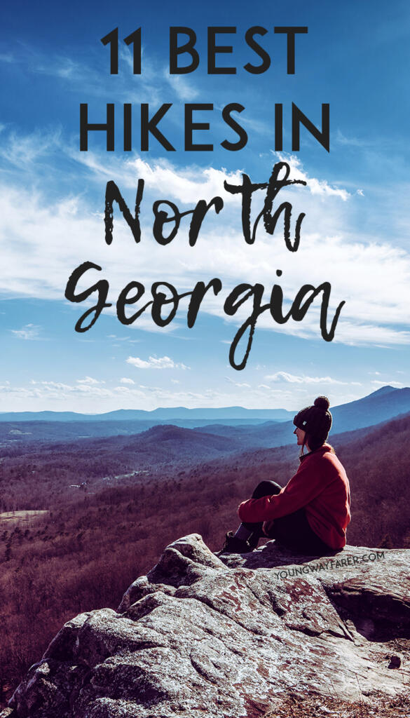
Favorite Hikes in North Georgia
I am so excited to share this post from my extensive research over the many years I’ve lived in Georgia. I’ve completed just about every popular trail in the Georgia mountains and these 11 are my absolute favorite hikes in Georgia!
Lula Lake Land Trust
Location: 120 miles northwest of Atlanta, near Chattanooga
Hike length: About a 3 mile loop (you can choose from a variety of trails)
Entrance fee: $15 per car. Only open the first and last weekends of the month. This is private property and the owners have a conservancy on their land, which is why there are limited open times. You must make a reservation online.
Good for dogs? Yes!
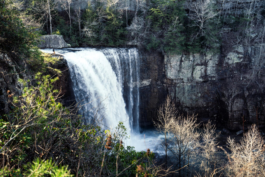
Trail description: This is probably my favorite hike in Georgia! When I arrived, I knew there was a beautiful waterfall. However, I wasn’t aware that there are some bluffs nearby with amazing views! Absolutely worth it to visit both on your short hike. When you arrive, you will receive a map with the several options of trails to go on. We chose the blue trail up to the top of the bluffs for some fantastic views. There is a bit of a climb, but nothing too difficult.


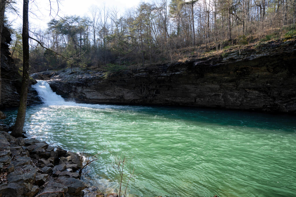
Then, we went down the purple trail to Lula Falls. We climbed down to the gorge floor to get a view of the falls from the bottom. There isn’t really a trail to do this, you have to navigate on your own. Next, we climbed up and got a view from the top. There is a trail that follows the river going back in the direction of the car that we chose. It goes by another smaller waterfall that goes into a gorgeous emerald-colored pool.

Lula Lake Land Trust is definitely worth a visit, but it takes some planning in advance! You will likely have to make your online reservation several weeks in advance.
Yonah Mountain
Location: 90 miles northeast of Atlanta
Hike length: 4.4 miles to top of mountain and back
Entrance fee: Free!
Good for dogs? Yes!
Trail description: In my opinion, this hike is the perfect length and difficulty, with a rewarding view at the top. I’ve done this hike several times. You pass a US Army training camp along the way to the top. At the very top of the mountain, there is a grassy meadow surrounded by trees that you can hang out in. To find the lookout spot, you must walk through the trees before reaching a cliff with a great view. There are several spots along the cliff, so everyone at the top can spread out and enjoy some relaxation time.


Blood Mountain
Location: 100 miles northeast of Atlanta
Hike length: 4.3 miles to top of mountain and back
Entrance fee: Free! Official trailhead parking is limited, but you can park along the side of US 19, as you will see lots of others doing on a nice weekend day.
Good for dogs? Yes!
Trail description: A classic, popular hike in north Georgia that has great views at the top. The trail starts from the Byron Reece trailhead and meets up with the Appalachian Trail at 0.7 miles. The summit is the highest point on the Appalachian Trail in Georgia. A must if you are hiking in the fall. You can see the beautiful colors for miles!


Springer Mountain and Benton MacKaye Loop
Location: 80 miles north of Atlanta
Hike length: 4.7 mile loop
Entrance fee: Free!
Good for dogs? Yes!
Trail description: Springer Mountain is where the Appalachian Trail starts (at the southern end). This loop is 4.7 miles and starts from the “Springer Mountain Parking for the AT” lot. From here, we went straight up to the Springer Mountain summit, which is only 0.7 miles from the trailhead. This was a good workout with some elevation gain, but the view at the top wasn’t great. Lots of trees prevented us from seeing much. I was slightly disappointed, but we wanted to finish the loop.
Coming back the way we came, the trail splits and we took the Benton MacKaye Trail to loop around and add some distance. There wasn’t much elevation change on this trail, and it was a beautiful walk through the woods. I still was hoping there would be a point that would have a good view. When we were about halfway through the loop, we noticed a small sign pointing to Owen’s Overlook. This was it: the view I’d been waiting for! It was also the perfect time to go because the fall colors were amazing! In the end, I’d recommend this hike, but only if you take the Benton MacKaye loop and don’t miss Owen’s Overlook.

Preacher’s Rock
Location: 80 miles northeast of Atlanta
Hike length: 2 miles to rock and back
Entrance fee: Free, but parking can be limited, especially on a nice day
Good for dogs? Yes!
Trail description: This is a great short hike in Georgia with a very rewarding view! It is great to add onto a day already in the mountains. The trail gains about 400 feet in the mile climb to the top. This is a short section of the famous Appalachian Trail. Follow the white AT blazes until you reach one of the best views in the state. My visit here was paired with a trip to a couple wineries nearby in the Dahlonega area.


Raven Cliff Falls
Location: 90 miles northeast of Atlanta
Hike length: 4.9 miles to falls and back
Entrance fee: $5 cash
Good for dogs? Yes!
Trail description: This is a nice length hike to see a Georgia waterfall. The hike climbs steadily, but not dramatically, with only about 600 feet elevation gain over the whole 2.5 miles. You will follow a creek the whole way until you eventually reach the falls. There will probably be lots of people around with kids playing in the water and some climbing to the top of the waterfall.
Panther Creek Falls
Location: 95 miles northeast of Atlanta
Hike length: 7 miles to falls and back
Entrance fee: $4 cash to park at trailhead
Good for dogs? Yes!
Trail description: Panther Creek is a fun hike! You cross over the creek a few times and hike along the edge a good part of the way. The hike is moderate with a few challenging parts, but not too tough overall. When we got to the waterfall at the end, we decided to wade through the pool beneath the falls and climb up the falls. It is very slippery up there, so use caution. The water is freezing, but it feels great on a hot Georgia day!


Fort Mountain
Location: 95 miles northwest of Atlanta
Hike length: 1.5 mile loop
Entrance fee: $5 per car to get into state park
Good for dogs? Yes!
Trail description: The views to effort ratio at Fort Mountain is great. With only a little elevation change, there is a lookout at the top, along with an amazing view over the trees. The mountain is near Ellijay, where there are several apple orchards. We paired this hike with apple picking for a full day in Ellijay!

Rabun Bald
Location: 120 miles northeast of Atlanta
Hike length: 3 miles to top of mountain and back
Entrance fee: Free but extremely limited parking. It will feel like you’re parking in someone’s driveway. Make sure you have the trailhead marked on your GPS.
Good for dogs? Yes!
Trail description: Rabun Bald is the second tallest mountain in Georgia and you will feel it! At only about 1.5 miles to the top, the 1000 feet of elevation is steady and relatively steep. Most of the hike holds views of the woods, but the view at the end is so worth the climb! There is a tower at the top that allows you to see 360 degree views above the treetops in every direction.


Amicalola Falls
Location: 70 miles north of Atlanta
Hike length: 2.1 miles to the top of the waterfall and back, or you can do a loop
Entrance fee: $5 per car to get into state park
Good for dogs? They are technically allowed, but most don’t like the hike. The majority is straight up grated stairs, which dogs typically hate. We took our dog and ended up carrying her the whole way!
Trail description: This is one of the more popular trails in Georgia. With its short length and views of an epic waterfall, it draws lots of people in. You will start the hike at the Visitor Center and reach a lovely reflective pool at about 0.5 miles. From here, the stairs begin, and you will go straight up. There is a nice viewing area part way up the falls that is a good spot to turn around if you don’t want to climb all the way to the top. If you want to continue the climb, you can complete the hike in a loop and climb back down on the east side of the falls.


Lake Conasauga
Location: 98 miles north of Atlanta
Hike length: 5.3 miles to tower and back
Entrance fee: Free and plenty of parking
Good for dogs? Yes! Even possible to let dogs off leash since there are so few people around.
Trail description: This is probably the most remote hike I’ve done in Georgia. The whole time we were hiking on a beautiful Saturday afternoon, we only saw a couple other people. The hike starts at the Lake Conasauga Picnic and Swim Site. We had packed a lunch and ate it on a bench along the trail, looking out at the lake. This moderate trail climbs to an old fire tower that is no longer in use. Hikers can climb up most of the stairs, but the top is blocked off.


North Georgia holds so many fantastic hikes within close proximity to Atlanta. I hope this guide helps you narrow down which ones you will love!
You may also be interested in:
Discover more from Young Wayfarer
Subscribe to get the latest posts sent to your email.